NASA Earth Observatory’s latest look at the Great Atlantic Sargassum Belt shows how satellite science is turning a seasonal ocean event into a near-real-time environmental signal. In a report published on July 29, NASA said the floating brown algae reached near-record levels across the belt in June 2026, while the Caribbean Sea and Gulf of America — also known as the Gulf of Mexico — reached regional records.
The finding is based on observations from the Ocean Color Instrument, or OCI, aboard NASA’s PACE satellite. According to the NASA Earth Observatory report, June 2026 was the second-highest year in the satellite record for the belt as a whole, just behind 2025. The result is significant because the belt is not a single, solid island of seaweed. It is a broad, shifting field of separate mats spread across the tropical Atlantic.
A record year in key regions
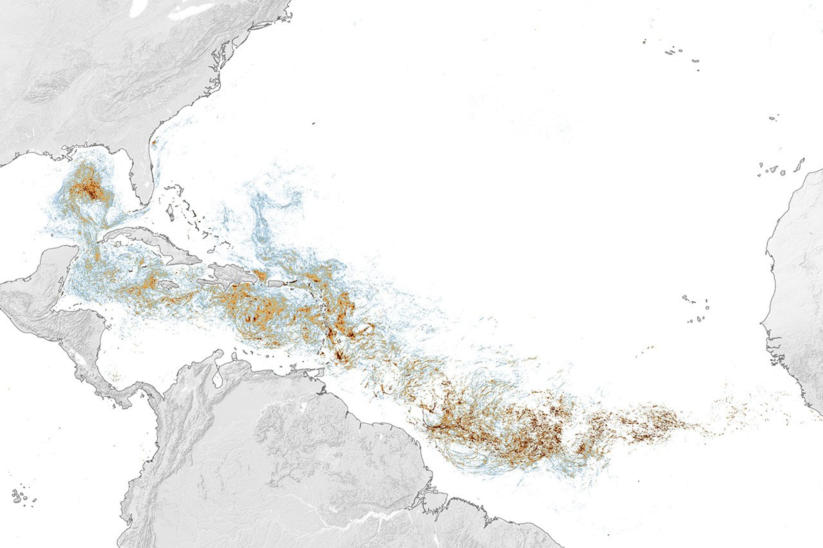
The latest estimate puts the western Caribbean at about 3.6 million metric tons of Sargassum in June, the eastern Caribbean at 9 million metric tons, and the Gulf at 5 million metric tons. NASA reports that both the Caribbean and the Gulf reached their highest regional levels in the available record. The Gulf total was nearly twice the previous regional record, which was also set in 2025.
Those numbers describe biomass, or the total mass of algae estimated across an area. They do not mean that every beach or coastline in the region experienced the same conditions. Winds and currents steer the mats unevenly, so a basin-wide peak can coexist with relatively light impacts in one coastal area and severe accumulation in another.
Why Sargassum can help — and harm
Offshore, Sargassum is part of a productive ecosystem. It provides food, shelter, and breeding habitat for fish, sea turtles, seabirds, and invertebrates. NOAA’s overview of Sargassum describes the floating algae as an important habitat in the open ocean, including for commercially valuable fish species.
The ecological balance changes when large quantities are carried toward shore. Near beaches, heavy mats can trap or suffocate marine life, shade or smother seagrass and coral, and interfere with coastal infrastructure. As the algae decomposes, it can release hydrogen sulfide, the gas associated with a rotten-egg smell. The risk is therefore tied not simply to the existence of Sargassum, but to its concentration, location, and stage of decomposition.
This distinction matters for public communication. A satellite map showing a strong signal in the open ocean is an early picture of supply and movement, not a guarantee that a particular beach will be covered. Local forecasts still depend on currents, winds, coastline shape, and nearshore conditions.
How PACE sees the belt from orbit
OCI detects Sargassum through the way its plant structure and chlorophyll reflect sunlight. Compared with clear seawater, the algae produces a stronger response in near-infrared wavelengths. Scientists identify pixels where that response rises above the background from seawater, then estimate how much of each pixel is covered by Sargassum.
Those coverage estimates can be converted into biomass, allowing researchers to compare different months and years. NASA’s map averages observations collected during June, so it represents a monthly view of a highly mobile surface phenomenon. It should not be read as a photograph of one continuous mat or as a precise count of individual rafts.
The longer record comes from the Moderate Resolution Imaging Spectroradiometer instruments on NASA’s Terra and Aqua satellites, with additional observations from the VIIRS instrument on NOAA-20. The record extends back to 2000. NASA says the Great Atlantic Sargassum Belt began developing in its present form around 2011, when the algae’s range expanded into the tropical Atlantic while becoming less concentrated in the North Atlantic’s Sargasso Sea.
PACE adds a more detailed view through OCI’s hyperspectral measurements. NASA reports that the instrument can distinguish Sargassum pixels across the Atlantic with greater confidence than earlier sensors in areas where other floating organisms may look similar. Its observations are now contributing to near-real-time daily and weekly maps used to follow short-term changes as well as long-term trends.
What to watch next
The June peak does not establish what the rest of 2026 will look like. NASA notes that observations not yet incorporated into the long-term chart showed Sargassum biomass declining through July. That is consistent with the belt’s seasonal cycle, which generally dips in winter and peaks in spring and summer, but it does not erase the significance of the strong early-year growth.
Scientists are still investigating why the belt has expanded so substantially. NASA identifies ocean warming, several possible nutrient sources, and interactions involving nitrogen-fixing bacteria as possible contributors, while making clear that the mechanism is not settled. That uncertainty is one reason continuous satellite monitoring is valuable: it helps researchers compare conditions across a whole ocean basin while giving coastal communities a clearer view of where risk may be moving.
The broader lesson is that the 2026 Sargassum event is both an ecological story and a measurement story. A living habitat can become a coastal hazard when transported in excess, and the same orbital observations that reveal the scale of the belt can support more targeted preparation on the ground. As PACE observations accumulate alongside the older NASA and NOAA satellite records, the Atlantic’s changing seaweed pattern should become easier to track — even if explaining every year’s peak remains a scientific work in progress.