NASA Earth Observatory has published two astronaut photographs that show wildfire smoke spreading across the Pacific Northwest and veiling the snow-capped volcanoes of the Cascade Range. The images, featured on 13 August 2026, place Mount Hood and Mount Rainier in the same frame as a much larger environmental story: smoke can travel far beyond the fire that produced it, changing the view, the air and the conditions on the ground.
The photographs were taken from the International Space Station in late July and early August. They are not satellite forecasts or air-quality maps, and NASA does not present them as a replacement for measurements taken on the ground. Their value is different: they provide a dated, wide-area view of how fire and smoke occupied the landscape at the moment astronauts passed overhead.
Two mountains, two smoke pathways
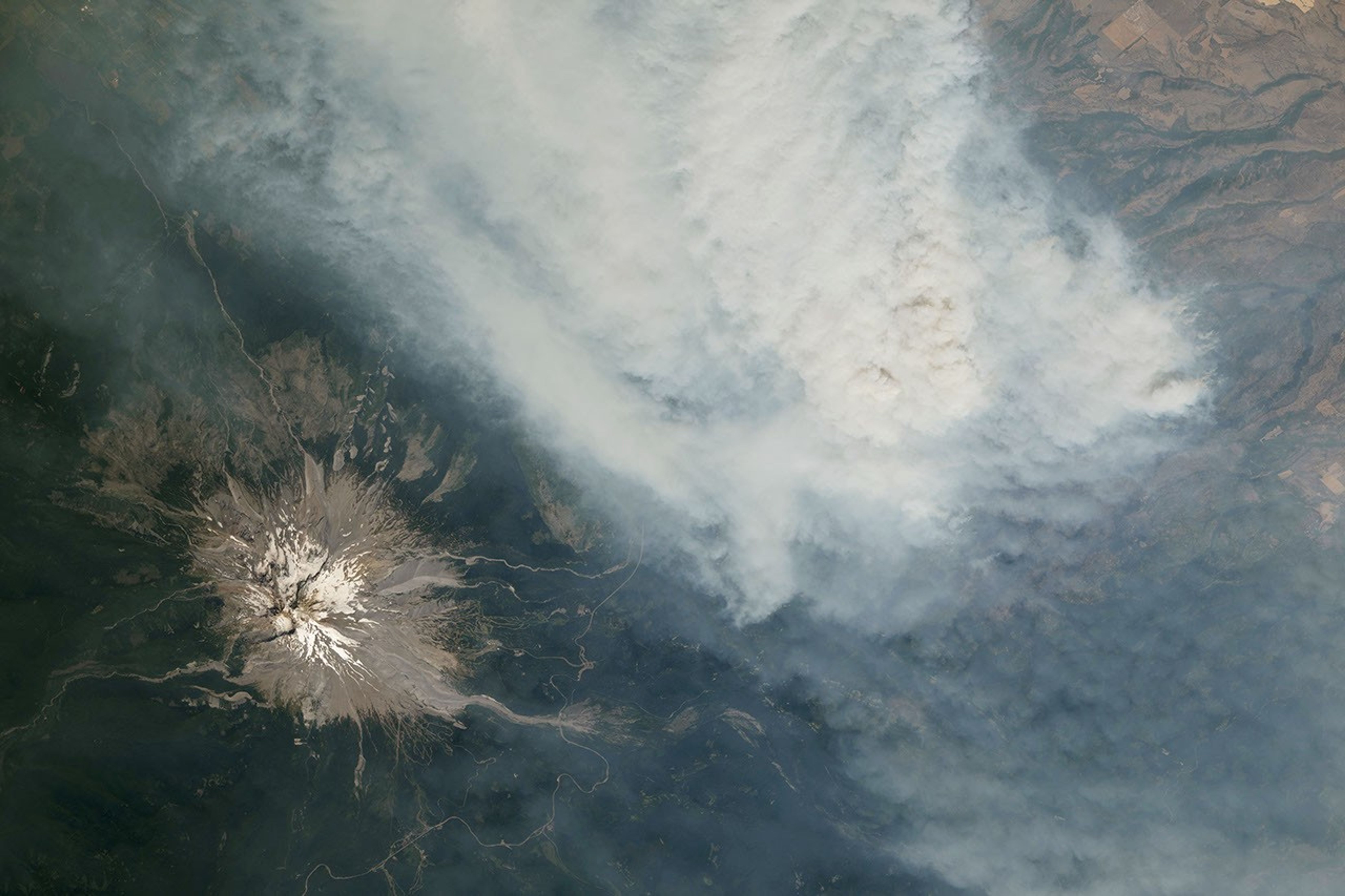
The first photograph was acquired on 31 July and shows Mount Hood, Oregon’s tallest peak, beside a broad plume from the Grasshopper Fire. NASA reported that the fire had burned nearly 84,000 acres, or about 34,000 hectares, by 12 August and had spread beyond the boundaries of the Mount Hood National Forest. Communities in Wasco County were under “go now” evacuation orders, while a nearby town was told to prepare for immediate evacuation.
The second photograph, taken on 4 August, shows Mount Rainier wrapped in smoke even though no major fire was burning close to the mountain when the image was captured. NASA says the smoke had drifted from fires in central and eastern Washington, carried by winds associated with a high-pressure system offshore. The National Park Service reported unhealthy air-quality conditions that day because of elevated fine particulate matter, known as PM2.5.
That contrast is the central message of the pair. One image shows smoke close to an active fire; the other shows how the same kind of pollution can arrive from elsewhere. A clear view of a landscape is not a reliable guide to the location of the source, and a fire does not need to be nearby for smoke to become an air-quality problem.
What an orbital photograph can — and cannot — tell us
From the station, the smoke appears as a pale, continuous sheet over forests, roads, farms and mountain slopes. The wide perspective makes the plume’s scale visible in a way that is difficult to capture from the ground. It also shows why location data matters: the photograph can be read alongside the fire’s date, the mountain’s position and official records of wind and air quality.
At the same time, the images have limits. NASA says they were cropped and enhanced to improve contrast, with lens artifacts removed. Colour and texture therefore help viewers see the scene, but they do not measure the concentration of particles or determine whether air is safe to breathe. For those questions, people should use current local guidance and monitoring rather than infer conditions from a photograph.
Each frame also carries a precise observation record. The images were taken with a Nikon Z9 digital camera using a 400-millimetre focal length and were provided by the ISS Crew Earth Observations Facility and NASA’s Earth Science and Remote Sensing Unit at Johnson Space Center. The photographs are linked to the agency’s astronaut photography archive, where the original observation can be identified by its mission and frame number.
A season shaped by fire weather
NASA’s report says above-normal fire potential was expected to persist across the Northwest through August. It describes a combination of warm, dry weather and cured fuels, with new fires able to start through lightning or human activity. The agency also notes that the wider conditions were influenced by El Niño. That is a description of the setting for these photographs, not a claim that one climate pattern alone caused either fire.
This distinction matters when reading dramatic Earth imagery. A single photograph can document where smoke was visible and how far it extended, but it cannot by itself establish a long-term trend or attribute an individual fire to climate change. Its strongest contribution is observational: it preserves a moment that can be compared with fire perimeters, weather records, air-quality readings and later images.
Why the ISS keeps looking down
NASA says the space station’s laboratory supports a programme that helps astronauts photograph Earth in ways that are useful to scientists and the public. Those observations complement satellites and ground instruments by adding flexible, human-directed views of fast-changing events. In this case, the photographs connect a wildfire emergency, two iconic volcanic landscapes and the movement of smoke across state lines.
The result is a reminder that the atmosphere does not follow the boundaries used on a map. The most useful reading of these images is therefore not simply that smoke obscured two volcanoes. It is that an event measured at one fire can become an air-quality and visibility story for a much wider region — and that an orbital viewpoint can make that connection visible.