NASA satellite observations show that the Great Atlantic Sargassum Belt reached near-record levels in June 2026, with the Caribbean Sea and the Gulf of America registering their highest amounts in the satellite record. The finding does not describe a single continuous mat of seaweed. It is a basin-scale estimate of scattered floating algae, and its local effects can vary sharply with currents, wind and shoreline geography.
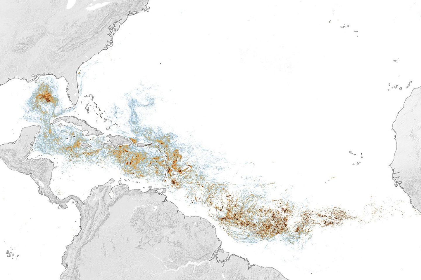
The latest assessment comes from NASA Earth Observatory, which published the analysis on July 29. Researchers used measurements from the Ocean Color Instrument (OCI) aboard NASA’s PACE satellite to map the June concentration of Sargassum across the tropical Atlantic. NASA’s report also places the 2026 observations in a longer record assembled from the Moderate Resolution Imaging Spectroradiometer, or MODIS, which has tracked the bloom’s biomass since March 2000.
A large bloom with record regional concentrations
NASA reports that the belt’s total June abundance was the second-highest in the satellite record, just below the record set in 2025. The regional picture was more extreme. The western and eastern Caribbean contained an estimated 3.6 million and 9 million metric tons respectively, while the Gulf of America reached about 5 million metric tons—nearly twice its previous record, also set in 2025.
Those figures describe estimated biomass, not a precise count of individual plants. Satellite instruments detect how much of the ocean surface is covered by floating Sargassum, then scientists use the observations to estimate the total mass represented within each pixel. The method is valuable because the belt can extend from West Africa toward the Caribbean and the Gulf while remaining patchy at smaller scales. A map can therefore reveal the regional pattern that would be impossible to capture from boats or beaches alone.
NASA cautions that the apparent continuity of the belt should not be read literally. The map’s red and orange areas indicate higher average density, but separate mats may be spread across the same broad region. Currents and winds can concentrate those mats near one coast while leaving another coast comparatively clear.
Why the increase matters near shore
In moderate quantities offshore, Sargassum is part of the marine ecosystem. The floating algae provide habitat for turtles, fish, invertebrates and seabirds, and they contribute oxygen through photosynthesis. The same material can become disruptive when large quantities accumulate close to shore.
Dense mats may interfere with marine life, and sinking material can cover coral and seagrass habitats. On beaches, decomposing Sargassum releases hydrogen sulfide, a gas associated with the familiar rotten-egg smell and a potential concern for coastal ecosystems and tourism. These impacts are highly local: a record basin-wide estimate does not mean every beach will experience record accumulation.
That distinction is important for interpreting the headline. NASA’s data show where the conditions for high concentrations were present; they do not provide a beach-by-beach forecast. Local exposure depends on the route taken by floating mats, shoreline shape and wind direction.
A trend that satellites can keep watching
The 2026 result sits within a longer change in the Atlantic. NASA’s analysis says the belt has expanded substantially since it first became apparent in 2011 and that total Sargassum has more than doubled every five years. The record is not a smooth climb: biomass rises and falls seasonally, usually reaching its highest levels in spring and summer. The July 2025 peak was followed by a rapid increase during the first four months of 2026, culminating in June’s near-record reading. Later observations cited by NASA indicated that biomass declined through July.
PACE adds a newer capability to that monitoring effort. Launched in February 2024, the satellite’s OCI can observe ocean color across broad areas and help distinguish floating material from surrounding water. NASA describes the instrument as part of a wider effort to understand ocean ecosystems and changing conditions from space. The PACE mission overview explains how those observations are used to study ocean biology, aerosols and clouds alongside phenomena such as Sargassum blooms.
The practical value of the record is not a promise that satellite maps can predict every local arrival. It is that repeated, comparable observations make it possible to identify unusually large seasons, compare regions and give coastal researchers a common picture of a phenomenon that moves across national boundaries. For 2026, the verified signal is clear: the Atlantic bloom was close to its record level overall, and several important regions exceeded their previous high.
NASA’s report is therefore best read as a measurement update, not as a universal warning for every coastline. It documents the scale and distribution of the bloom, while leaving local authorities and coastal scientists to assess what those conditions mean on the ground.