NASA Earth Observatory has published new astronaut photography that puts a fast-moving Pacific Northwest wildfire season into a striking geographical frame: smoke spilling across the slopes of Mount Hood and Mount Rainier, two ice-capped volcanoes that usually dominate the landscape from afar. The images do not show a single fire front. They show how smoke can travel across a much wider region, crossing mountain ranges and obscuring landmarks separated by rugged terrain.
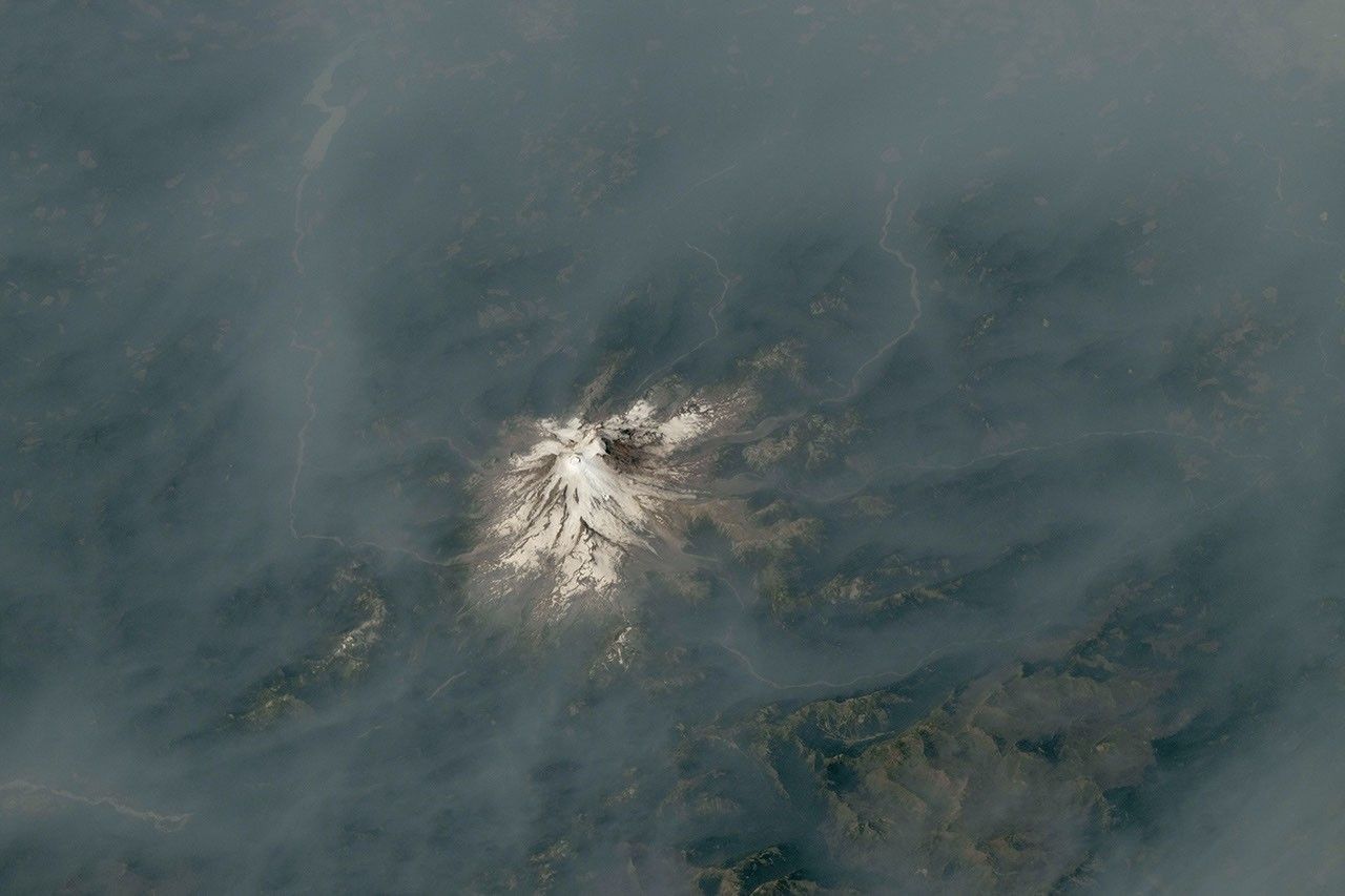
The NASA report published on Aug. 13 describes two photographs taken by astronauts aboard the International Space Station. One was acquired on July 31, 2026, and shows Mount Hood near a broad plume from the Grasshopper Fire. The second was taken on Aug. 4 and shows Mount Rainier surrounded by haze drifting from fires farther east in Washington.
What the orbital view reveals
Mount Hood rises to 11,249 feet (3,429 meters) and is Oregon’s tallest peak. NASA says a lightning strike on July 23 ignited the Grasshopper Fire east of the mountain, after thunderstorms moved through the area. By Aug. 12, the fire had burned nearly 84,000 acres (34,000 hectares) and had spread beyond national-forest boundaries. Evacuation orders were in effect for several communities in Wasco County, while the nearby town of Dufur was told to prepare for a possible immediate evacuation.
The Mount Rainier image tells a different but connected story. When the photograph was taken, on Aug. 4, no major fire was burning close to the volcano. Instead, smoke had travelled from central and eastern Washington. NASA attributes the transport to easterly winds associated with a high-pressure system offshore. The National Park Service reported unhealthy air in the park that day because of elevated concentrations of fine particulate matter, commonly called PM2.5.
Several days later, NASA noted, the Grand Park 2 Fire was burning inside Mount Rainier National Park, about three miles north of the Sunrise Visitor Center. The fire had reached 223 acres (90 hectares) and remained uncontained as of Aug. 12. That sequence matters: a smoky view from orbit can reflect both distant emissions and new activity closer to the photographed landscape.
A season shaped by dry fuels and fire weather
The photographs arrive as the National Interagency Fire Center’s August outlook identifies above-normal significant fire potential across the Northwest. The agency’s assessment points to warm, dry conditions, ongoing drought, and fuels that have cured across much of the region. It also expects above-normal potential to continue through September in Oregon and Washington, while emphasizing that the eventual size and behavior of any fire still depend on local weather, fuels, terrain, and ignition.
NASA’s Earth Observatory connects the immediate conditions around the Cascade Range to a broader seasonal pattern. The agency says weather influenced by El Niño, combined with dry vegetation, helped create conditions in which lightning- or human-caused ignitions could develop into large, long-burning fires. That is context, not a claim that El Niño alone determines the outcome. Fire behavior remains highly local, and a forecast of elevated potential is not a prediction that every community will experience a major fire.
Why photographs from the ISS are useful—and limited
Astronaut photography is not a replacement for satellite-based fire detection, smoke modelling, or ground-based air-quality monitoring. It is a visual record collected from a human-tended laboratory moving over the Earth. NASA says the two images were taken with a Nikon Z9 digital camera and a 400-millimeter focal length by members of the Expedition 75 crew. They were later cropped and enhanced to improve contrast, with lens artifacts removed.
That processing makes the mountains and smoke easier to see, but it also reinforces an important limitation: the pictures are not live maps. They were acquired days before the NASA story was published, and they do not provide a current evacuation boundary, a precise concentration of PM2.5, or a forecast of where the plume will move next. Anyone making a safety decision should consult current instructions from local emergency managers and official air-quality services.
The value of the images is their scale. From the ground, smoke can look like a local nuisance or a distant veil. From orbit, it becomes a regional signal linking active fires, wind patterns, dry fuels, and communities separated by rugged terrain. The photographs also make clear why a clear view of a mountain is not the same thing as clean air: the source of the smoke may be far away, and the conditions at the ground can change faster than a single image can show.
NASA’s latest release therefore works as both an environmental snapshot and a reminder about how to read Earth-observation imagery. It documents what astronauts saw above the Pacific Northwest at specific moments in late July and early August. The operational picture today must come from updated fire reports, weather forecasts, and air-quality measurements—but the orbital perspective shows how quickly a local ignition can become a regional atmospheric story.