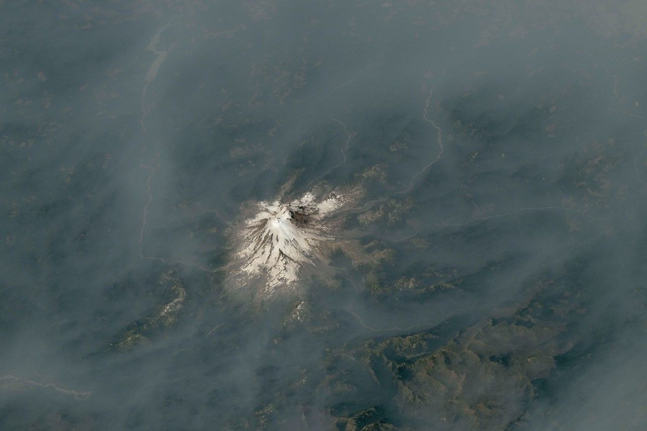
NASA Earth Observatory has published a new view of wildfire smoke spreading across the Pacific Northwest: astronaut photographs from the International Space Station show Mount Hood and Mount Rainier partly obscured by brown-gray haze. The images place two of the Cascade Range’s best-known, glaciated volcanoes inside the same regional story—one shaped by active fires close to the mountain, the other by smoke transported from fires farther away.
The contrast matters because a photograph from orbit can show the scale and continuity of an event that is harder to see from the ground. In its Earth Observatory report, NASA describes the images as an “in contrast of fire and ice” view of a summer fire season in which dry fuels, lightning ignitions and wind helped smoke move across Oregon and Washington.
Smoke rises beside Mount Hood
One photograph, acquired on July 31, shows Mount Hood, Oregon’s tallest peak, standing near a thick plume from the Grasshopper fire. NASA reports that lightning on July 23 ignited the blaze east of the mountain. Hot, dry conditions then helped it spread quickly across the Mount Hood National Forest and beyond its boundaries.
By Aug. 12, the Grasshopper fire had burned nearly 84,000 acres, or about 34,000 hectares, according to the information summarized by NASA. Several communities in Wasco County were under “go now” evacuation orders, while the nearby town of Dufur was told to prepare for an immediate evacuation. The astronaut view does not replace incident maps or local instructions, but it makes the relationship between the fire, the mountain landscape and the smoke plume immediately visible.
Rainier shows the reach of transported smoke
A second photograph, taken on Aug. 4, shows Mount Rainier in Washington surrounded by haze. NASA notes that no major fire was burning close to the volcano when the image was captured. Instead, smoke had drifted from fires in central and eastern Washington, carried by winds associated with a high-pressure system offshore.
That distinction is important. Poor air quality does not necessarily indicate that a fire is burning next to a community or landmark. Smoke can travel across large distances, and the health risk depends on the concentration of fine particles as well as on how long people are exposed. NASA reports that the National Park Service recorded unhealthy levels of fine particulate matter, known as PM2.5, at the park that day. Current conditions can change quickly, so people in affected areas should rely on local air-quality and emergency-management updates.
What the ISS photographs add
The images were taken by a member of the Expedition 75 crew using a Nikon Z9 digital camera with a 400-millimeter focal length. NASA says the photographs were supplied through the ISS Crew Earth Observations Facility and the Earth Science and Remote Sensing Unit at Johnson Space Center. They were cropped and enhanced to improve contrast, and lens artifacts were removed before publication.
This is a different kind of observation from a satellite instrument. A camera operated by an astronaut can capture a high-resolution, oblique view that connects a recognizable mountain to the smoke around it. Instruments designed for mapping and measurement remain essential for detecting active fires, estimating burned area and tracking air pollutants, but photographs can provide a clear visual record that helps the public understand those datasets.
The broader value is cumulative. NASA makes astronaut photography available through the Gateway to Astronaut Photography of Earth, creating an archive that can be compared with later images, satellite observations and information from ground agencies. Used together, these sources help distinguish a local fire plume from smoke transported across a region.
A regional signal, not a single-fire snapshot
NASA’s account also places the photographs in a wider seasonal context. The National Interagency Fire Center’s August-through-November outlook forecast above-normal significant fire potential across much of the Northwest. That forecast is not a prediction of the exact location or severity of an individual fire. It is a planning tool that combines current and expected weather, drought and fuel conditions.
For the Cascade Range, the ISS images bring those regional factors into focus. A single frame contains snow and ice that persist at high elevation, dry forests below, and a smoke layer shaped by fires and winds across a much larger area. The scene is visually striking, but its real significance is practical: wildfire smoke is both a landscape signal and an air-quality hazard, and observing it requires information from orbit, aircraft, field teams and local monitors.
As fire activity continues to evolve, the photographs offer a precise snapshot of conditions observed in late July and early August—not a live forecast. Their strongest contribution is to document how quickly a familiar mountain environment can be altered by smoke, while showing why coordinated Earth observation remains central to understanding wildfire behavior and its effects on people and ecosystems.